College of Engineering Guindy, Anna University | 2021
GIS-Based Seismic Hazard and Building Vulnerability Assessment for Chennai
Scenario-based seismic vulnerability screening using dynamic structural response modeling, regression methods, and GIS analysis.
Context
Chennai is a large, dense urban region where comprehensive building-by-building seismic evaluation is not feasible at city scale. At the same time, meaningful differences in structural vulnerability can arise from variations in building geometry, height, and dynamic response under seismic loading.
This project was motivated by the need for a scalable assessment framework that can translate simplified structural response calculations into actionable, city-wide insights. Rather than performing detailed nonlinear analysis for every structure, the work focuses on identifying relative patterns of vulnerability using a combination of representative building models, regression-based generalization, and spatial analysis.
Approach
The study adopted a scenario-based framework to relate seismic demand to structural response using a representative set of building models. Base shear response was evaluated for buildings with varying plan areas, aspect ratios, and heights through dynamic structural analysis, producing a dataset that captures how key geometric attributes influence seismic demand.
These results were used to train a support vector regression model that predicts base shear as a function of building attributes available at city scale. The trained model was then applied across the study area, and the resulting predictions were integrated within a GIS environment to examine spatial patterns of relative building vulnerability.
Implementation & Tools
Structural modeling dataset
- Defined a representative set of buildings with varying plan area, aspect ratio, and number of storeys.
- Performed dynamic structural analysis to compute base shear and related response quantities.
- Extracted response metrics to form a training dataset linking geometry to seismic demand.
Regression and generalization
- Trained a support vector regression model to predict base shear from geometric building attributes.
- Tuned model parameters to balance accuracy and generalization for city-scale application.
- Evaluated prediction performance using goodness-of-fit measures reported in the study.
Spatial integration
- Applied the trained regression model across the study area using available building attribute data.
- Integrated predicted responses into a GIS environment for spatial analysis.
- Visualized relative patterns of building vulnerability to support screening and prioritization.
Tools
- ETABS; Structural analysis software for dynamic response modeling of representative buildings.
- Python for regression modeling, data processing, and analysis.
- ArcGIS; GIS software for spatial joins, mapping, and visualization.
Results
Results are intended for relative screening and comparison, not building-specific performance assessment.
The results examine how seismic base shear varies with building height and geometry, and how effectively regression-based models reproduce structural response at city scale. All results are interpreted as relative indicators suitable for screening.
Structural response trends
Dynamic analyses of the representative building set show systematic increases in base shear with plan area, aspect ratio, and number of storeys. Taller buildings exhibit higher demand and greater sensitivity to geometric variation.
Design vs. scenario-based base shear comparison
The figures below compare design base shear and scenario-based base shear for representative low-rise and mid-rise buildings. Results are shown for one-storey buildings (left) and five-storey buildings (right).
- For one-storey buildings, predicted base shear shows closer agreement with design-level values, indicating that geometric attributes capture a large portion of the response variability.
- For five-storey buildings, larger deviations are observed, reflecting increased dynamic complexity and reduced predictive fidelity.
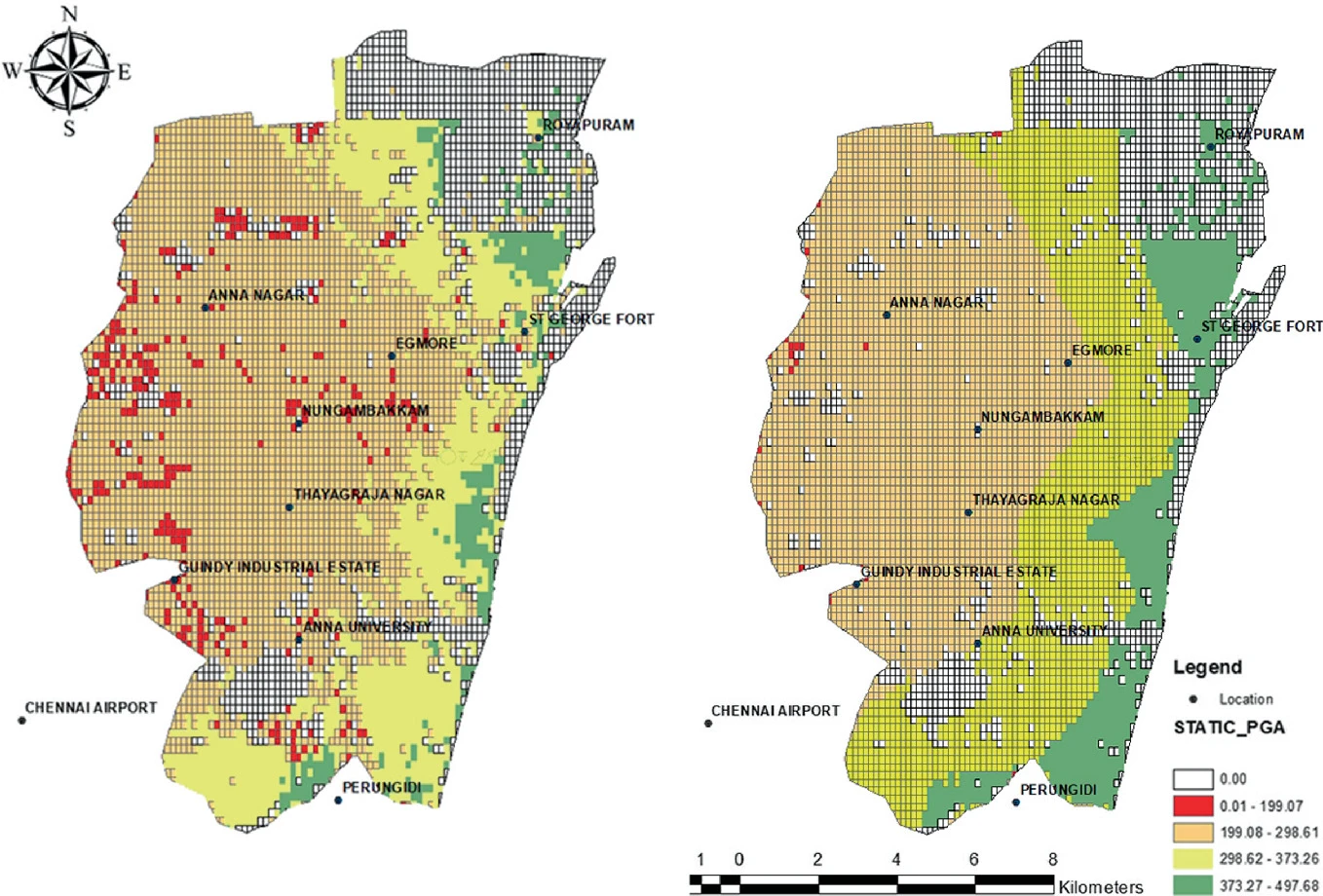
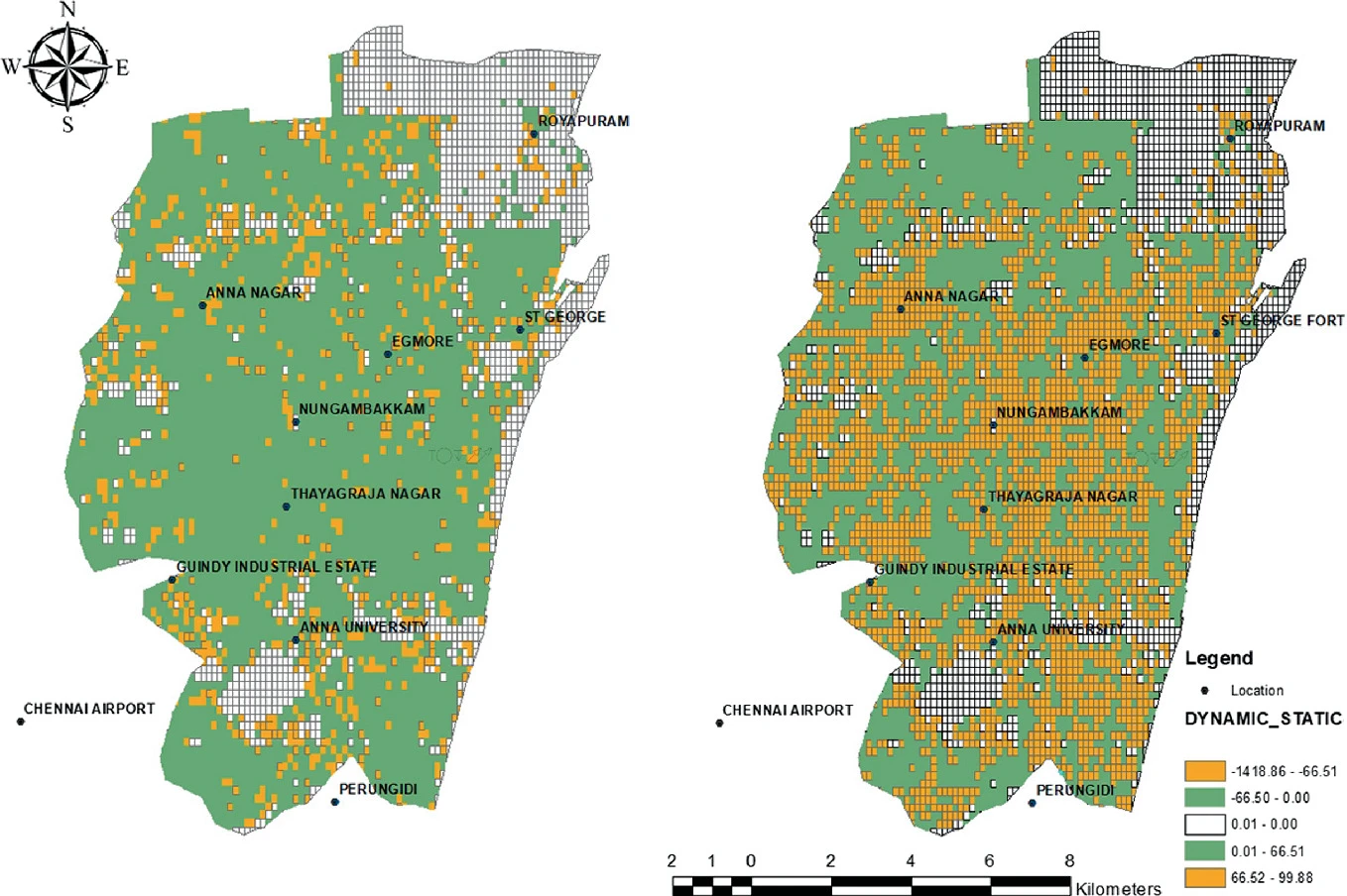
Spatial patterns
Mapping predicted responses within a GIS framework reveals non-uniform spatial distributions of relative building vulnerability. For the modeled building stock, coastal regions exhibit comparatively lower vulnerability indices than inland areas, supporting the use of the method for prioritization rather than absolute assessment.
Analysis & Insights
The results show that simplified geometric descriptors capture a substantial portion of seismic base shear response for low-rise buildings, enabling effective regression-based generalization at city scale. As building height increases, deviations between predicted and modeled response become more pronounced, reflecting the influence of higher-order dynamic effects that are not fully represented in reduced-order predictors.
These trends highlight a clear tradeoff between scalability and fidelity. The approach is well suited for rapid screening and prioritization, where relative comparisons are sufficient, but it also delineates the limits beyond which more detailed structural modeling is required. This distinction is critical when using city-scale analyses to guide follow-up investigation rather than replace building-specific evaluation.
What This Demonstrates
- Ability to abstract complex structural response into reduced-order models suitable for large-scale analysis.
- Use of regression methods to generalize physics-based simulation results beyond a limited modeled dataset.
- Judgment in balancing model fidelity and scalability when operating under data and computational constraints.
- Translation of numerical model outputs into spatially interpretable results for decision support.
Recognition
Best Paper Presentation Award, 5th International Conference on Architecture and Civil Engineering, Singapore, August 2021.